March 12, 2013

Day Seven

Last night I attended a meeting with the Natural Lands Preservation Advisory Board. The meeting began by electing a new president and vice president for the board and the approval of the minutes from the last meeting. Then the board discussed community member comments on the Horse Gulch Management Plan. Major concerns were adding different types of biking trails, more aggressive trails and if dogs should be allowed to be off leash. It was decided that the board supported the idea of rephrasing the signage and law to allow owners to have their dogs off lease if they are under voice control. If not they could be ticketed. This would require the changing of laws and signage. This gave a transition to discussion over how the wildlife that populates that area is being affected by the increase in human activity. Talks about the balance between recreation and wildlife lead to the topic of seasonal closures and that was going to be researched more and brought up at later meetings. The Oxbow Park and Preserve was the next topic on the agenda. Many members of the public had showed up that lived near the Park and Preserve. There was some debate over what language of the conservation easement and a small community need to have more input during the purchasing of the property. There was also a comment made that there should also be a plan for how to protect the wildlife on the property and this should be as important as the other developments that may be occurring on the Sherman Parcel and the Oxbow Park and Preserve.
Today I started off by attempting to translate my conceptual idea that I had in my head and had sketched out onto a map in the GIS program. I had exponentially more success today than I did yesterday. I refined the natural surface trails and the River Trail and added the turn around, Parking areas, River Trail access and the Trail head. I am going to talk with Scott, the landscape architect, on Thursday, about my design. I conducted my mentor interview today and Steve Smith my Chemistry teacher stopped by the office.  
Updated Trail System (in yellow)


Dirt Road and Turn Around for Buses and Trailers (in green)

Parking areas (in orange)
 Tomorrow I am going to refine my conceptual design more however I am attending the Green Business Round table at the Strater and then I have a River Watch lab with Steve so I will be quite busy.

These designs are not final and do not reflect views of the City of Durango.

March 11, 2013

Day Six, Week Two

Today I started at home working on my conceptual design using the GIS software. I made some minor changes to the Oxbow Park and Preserve boundaries and added a natural surface trail system. After I arrived to the office I began to look at my original sketch and realised that the River Trail didn’t flow very well, there were too many sharp turns. To remedy this I made it cross the dirt road farther north. Another issue I ran into was how to get pedestrians and others to the River Trail from Animas View Drive. One idea was that there could be an extension that passed through the Sherman Property but this would cut off half of the parking because cars couldn’t cross the trail. Another option would be to have the River trail follow the perimeter of the Sherman property. This would allow for more parking but would create poor flow on the River Trail.

New Property Boundaries


Natural Surface Trail


I am going to be attending a Natural Lands Preservation Advisory Board Meeting at the Library tonight. For tomorrow I am going to focus on the River Trail and how it will pass through these two properties.

These designs are not final and do not reflect views of the City of Durango.

March 8, 2013

Day Five, We are Making Progress


Today I finished the outline of the process the city goes through to develop a property. I worked on the outline until my meeting with Kevin at 11:30 where we discussed what I had so far. Kevin helped by adding little bits of information here and there that I had missed and insured that what I had was accurate. He also gave me the 2001 Master Plan to look through to help me distinguish how the property came to be of interest to the City of Durango. After the meeting I went back to my work space and synthesized what we had talked about into words and put that into my outline. I then took a break from the outline and started doing some very basic sketches of what I think my conceptual design will look like. As you can see it’s a little disorganized but I started exploring the GIS technology and this will make my design much clearer.


At this point I only have the boundaries of the Sherman Parcel and the Oxbow Park and Preserve but on Monday I am going to start adding some of the basic pieces like the Roads and the Railroad tracks and possibly parking lot on the Sherman Parcel.

These designs are not final and do not reflect views of the City of Durango.

March 7, 2013

Day Four

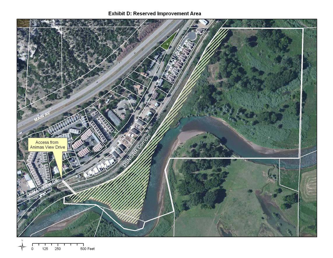
Kevin was called in for jury duty today so as a result came to work a little later. This gave me time to read over the GOCO Grant Application Selection Criteria for Submittal document. After he arrived we discussed questions I had concerning the difference between buying an easement and buying a fee interest. If a landowner sells a conservation easement they still maintain ownership over the property but they have given up rights to develop and build on that property. However if they city buys a fee interest then they own the property and the previous landowner does not have any responsibilities in relation to the land. I also found it interesting that if a landowner donates property for a conservation easement they receive a tax deduction. This tax deduction is determined by the difference of the value of the property if it was developed or not but if the landowner does not pay that amount of money in taxes they can sell the tax credits to other people! Today I also found out that the Sherman parcel located on the other side of the train tracks is not a part of the conservation easement so it can be developed.


Sherman Parcel
Tomorrow I am going to continue research and the explanations of the individual pieces of the process.


March 6, 2013

Day Three

Today I started by having a meeting with Kevin. We discussed questions I had regarding the location of the easement and how it could be used. The hatched markings on the map represent an area that has different restrictions on how it can be developed and used. Then Kevin described to me how sales tax was initiated by a need for a Recreation Center and the River Trail in 1999 and how another sales tax was passed in 2005. Then we talked about the how the Parks and Recreation Advisory Board and the Natural Lands Advisory Board influence the Cities decisions and direction. Also I learned that last night after a series of failed attempts an agreement was made on the name of what was formally known as the Sherman and Cameron/Sterk parcels, The Oxbow Park and Peserve. This encompasses 43.71 acres of land on both sides of the railroad tracks and the river.


Map Of Oxbow Park and Preserve
Tomorrow I am going to work on explaining one aspect of the process in detail and insuring that how I have organized my steps makes sense and is chronologically accurate.

March 5, 2013

Day Two


Today Kevin was out of the office on a series of meetings so I continued doing research using the City of Durango Parks, Open Space, Trails and Recreation Master Plan and the Durango Animas River Management Plan. In these documents I focused on community input and community need. These forces are what drive and guide the city when planning projects. Community input is a critical piece of the entire process. It can be the initiator, if a community member brings up an issue, it can shape the design, what the public wants out of the project and it can expedite the project, based on how important the product will be. In the case of Cameron/Sterk property more river access and put-ins and the conservation of the ecosystems located by the river was needed and this was voiced by the community. Then the public participated in creating the master plan that dictates the framework for how development should advance and finally community members are participating in the type of development that will occur on that property.

Tomorrow I am going to begin creating a diagram that shows the process the city goes through from acquiring land to maintaining the final product. After the basic outline has been made I am going begin applying it to the Cameron/Sterk property.
.


March 4, 2013

1st Day!

 Today I began by getting a broad understanding of the process that the city goes through from acquiring the land to finalizing the plans to developing and building on that property. I also gained a better understanding of the different people in the process and the role they play in it. For today I investigated the master plan formulated in April of 2010 and began to look at the initial phases of the Cameron Sterk Property. This included the conservation easement and the environmental site assessments. One thing I found that I found interesting was approximately 20 cars and car remints were found during the Phase 1 Environmental Assessment to have been dumped near the river to reduce erosion. The Phase 2 Environmental Assessment reviled that there was minimal contamination and therefore should be left in place.
 
Tomorrow I am going to determine what the community wants from the Cameron/Sterk property.